FireSat
A global coalition led by nonprofit Earth Fire Alliance to create breakthroughs in wildfire detection and monitoring.
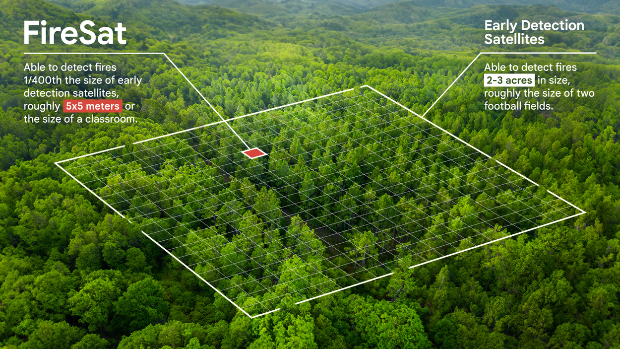
Satellite imagery currently used for active firefighting is often low resolution or only updated a few times a day, making it difficult to detect fires smaller than a soccer field. To address this challenge, Google Research contributed to the design of FireSat alongside space systems company Muon Space, which builds and operates the satellites on behalf of the nonprofit Earth Fire Alliance.
FireSat is a satellite constellation designed specifically to detect and monitor wildfires. When the full constellation is operational, it will enable the detection of wildfires as small as 5 x 5 meters, anywhere on Earth, with updates every 20 minutes or less.
The FireSat program uses high-resolution multispectral infrared imagery and applied AI to provide near real-time wildfires insights. It enables faster detection, improved situational awareness for first responders, ultimately helping to reduce the devastating impacts of wildfires.
Google.org also facilitates the AI Collaborative: Wildfires, an initiative that brings together public, private, and nonprofit organizations to help communities identify and track wildfires using AI. FireSat will provide highly detailed insights, useful data for ecological intervention, and novel ground truth that will allow scientists and AI experts to better understand fire propagation and risk.
The FireSat prototype, Protoflight, launched from Vandenberg Space Force Base in California aboard SpaceX's Transporter-13 mission in March 2025 to test and validate the system’s design and data product workflow. It has since detected fires of various types and sizes across five continents, including a small, cool fire in the Western U.S. that existing satellite systems were not sensitive enough to identify.
The first three operational FireSats are scheduled to launch in the summer of 2026. The full FireSat constellation will follow in the coming years as additional satellites are deployed in stages.
FireSat is a purpose-built satellite constellation to focus on wildfire detection and monitoring using high resolution infrared data.
Google and other organizations will apply AI to FireSat data to compare the current image with the prior thousand images of the same spot, take local weather and other factors into account, and then reliably determine if a fire is present in the image. In addition to supporting emergency response, the data will also be available to scientists working to understand and predict the nature of fire growth and other behaviors.
To catalyze this groundbreaking initiative, Google.org has provided more than $15 million in funding to support the work led by Earth Fire Alliance. Fellow Earth Fire Alliance supporters and partners include the Gordon and Betty Moore Foundation and the Bezos Earth Fund.
FireSat represents the latest addition to Google Research’s efforts to improve wildfire tracking and understanding, ultimately benefiting global communities.
Earth Fire Alliance is still building out its global coalition and welcomes new partners. Reach out to Earth Fire Alliance to learn more about how to support its mission.

The first three FireSats which are scheduled to launch summer of 2026

