FireSat
A partnership led by Earth Fire Alliance to use AI to create a breakthrough in wildfire detection.
FireSat uses high-res multispectral satellite imagery and AI to provide near real-time insights on wildfires. It enables faster detection, improved situational awareness for first responders, and ultimately helps to reduce the devastating impacts of wildfires.
FireSat uses high-res multispectral satellite imagery and AI to provide near real-time insights on wildfires. It enables faster detection, improved situational awareness for first responders, and ultimately helps to reduce the devastating impacts of wildfires.
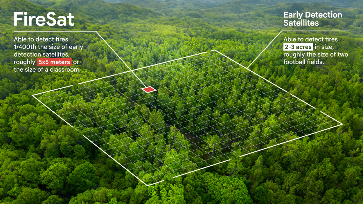
Satellite imagery that’s currently used for active firefighting is available at a low resolution or only updated a few times a day, making it difficult to detect fires smaller than a soccer field. To address this challenge, Google Research has been partnering with the Earth Fire Alliance, the Gordon & Betty Moore Foundation and Muon Space to develop FireSat, a purpose-built satellite constellation. FireSat will provide highly detailed insights, useful data for ecological intervention, and novel ground truth that will allow scientists and machine learning experts to study fire propagation and risk.
The FireSat Alliance is still being built and welcomes new partners. Reach out to Earth Fire Alliance to learn more about how to support the alliance.
The very first prototype FireSat launched from Vandenberg Space Force Base in California aboard SpaceX's Transporter-13 mission in March 2025. It detected a small cool fire that was not detected by other satellite systems.
FireSat is a constellation of satellites dedicated entirely to detecting and tracking wildfires. When the full constellation is operational, it will provide global high resolution imagery that is updated every 20 minutes, enabling the detection of wildfires that are roughly the size of a classroom.
FireSat is the first satellite constellation to focus on early detection in high resolution imagery.
FireSat uses AI to compare the current image with the prior thousand images of the same spot, takes local weather and other factors into account, and then reliably determines if a fire is present in the image. In addition to emergency response efforts, the data will also be available to scientists working to understand and predict the nature of fire growth and other behaviors. FireSat will offer a valuable new dataset to scientists to improve wildfire behavior modeling.
To get started on this groundbreaking initiative, Google.org has provided $13 million in funding to support the work led by the Earth Fire Alliance, a non-profit established to launch the FireSat constellation in partnership with the Moore Foundation. Muon Space has built, owns and operates the first FireSat protoflight mission. The full FireSat constellation will follow in the coming years. We plan to utilize this data into our partnership with the U.S. Forest Service to expand our existing work on fire simulation.
FireSat represents the latest addition to Google Research’s efforts to improve wildfire tracking and understanding, ultimately benefiting communities around the globe.
Jason Forthover. Firefighter, USFS Researcher.

